Enregistrez gratuitement cette image
en 800 pixels pour usage maquette
(click droit, Enregistrer l'image sous...)
|
|
Réf : V01772
Thème :
Terre vue de l'espace - Déserts - Dunes (200 images)
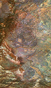
Titre : Space Radar Image of Safsaf Oasis, Egypt
Description : (La description de cette image n'existe qu'en anglais)
This three-frequency space radar image of south-central Egypt demonstrates the unique capability of imaging radar to penetrate thin sand cover in arid regions to reveal hidden details below the surface. Nearly all of the structures seen in this image are invisible to the naked eye and to conventional optical satellite sensors. Features appear in various colors because the three separate radar wavelengths are able to penetrate the sand to different depths. Areas that appear red or orange are places that can be seen only by the longest wavelength, L-band, and they are the deepest of the buried structures. Field studies in this area indicate L-band can penetrate as much as 2 meters (6.5 feet) of very dry sand to image buried rock structures. Ancient drainage channels at the bottom of the image are filled with sand more than 2 meters (6.5 feet) thick and therefore appear dark because the radar waves cannot penetrate them. The fractured orange areas at the top of the image and the blue circular structures in the center of the image are granitic areas that may contain mineral ore deposits. Scientists are using the penetrating capabilities of radar imaging in desert areas in studies of structural geology, mineral exploration, ancient climates, water resources and archaeology.This image is 51.9 kilometers by 30.2 kilometers (32.2 miles by 18.7 miles) and is centered at 22.7 degrees north latitude, 29.3 degrees east longitude. North is toward the upper right. The colors are assigned to different radar frequencies and polarizations as follows: red is L-band, horizontally transmitted and received; green is C-band, horizontally transmitted and received; and blue is X-band, vertically transmitted and received.The image was acquired by the Spaceborne Imaging Radar-C/X-band Synthetic Aperture Radar (SIR-C/X-SAR) on April 16, 1994, on board the space shuttle Endeavour. SIR-C/X-SAR, a joint mission of the German, Italian and United States space agencies, is part of NASA's Mission to Planet Earth program.
|
|

